
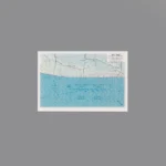
The item is a Custom Printed Map Tile accessory, which is designed for minifigures. This is a custom accessory featuring a detailed printed military tactical map. This specific map is a U.S. Army landing map for Utah Beach. It is labeled in the top right corner with “UTAH BEACH” and shows a detailed grid of the beach and the inland area, including roads and tactical information.
Background: The real Utah Beach was one of the five Allied landing zones for the D-Day invasion of Normandy on June 6, 1944, during World War II. It was the westernmost of the landing beaches, assaulted by the U.S. Army’s 4th Infantry Division. Tactical maps like this were issued to soldiers and officers so they could navigate the terrain, identify objectives, and coordinate their movements after landing on the heavily defended coast.
Reviews
There are no reviews yet