
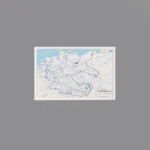
The item is a Custom Printed Map Tile accessory, which is designed for minifigures. This is a custom accessory featuring a detailed printed political map of post-war Europe. The map clearly shows Central Europe, with “GERMANY” and “POLAND” visible. The most prominent feature is the thick blue lines dividing Germany and the city of Berlin (visible as a separate divided area) into the four Allied occupation zones.
Background: After the unconditional surrender of Nazi Germany in May 1945, the victorious Allied powers (the United States, the United Kingdom, the Soviet Union, and France) divided the country and its capital, Berlin, into four separate occupation zones. This map represents this post-war arrangement, which was decided at the Yalta and Potsdam conferences. This division became the new political map of Europe and set the stage for the Cold War, eventually leading to the split between West and East Germany.
Reviews
There are no reviews yet