
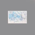
The item is a Custom Printed Map Tile accessory, which is designed for minifigures. This is a custom accessory featuring a detailed printed military campaign map. This map specifically depicts the Battle of the Scheldt. It shows the complex geography of the Scheldt Estuary in the Netherlands and Belgium, with large blue areas representing the sea and flooded regions (polders). The map is overlaid with tactical markings (arrows, lines, and unit positions) showing the Allied (primarily Canadian) and German forces’ positions and movements.
Background: The real Battle of the Scheldt was a brutal and critical military operation fought in the autumn of 1944 during World War II. After the Allies captured the port of Antwerp, the German army still controlled the 70-kilometer-long Scheldt estuary, blocking all shipping. The First Canadian Army was tasked with the difficult job of clearing this heavily defended and flooded landscape in a grueling, month-long battle. The successful operation opened Antwerp to Allied shipping, which was vital for supplying the final push into Germany.
Reviews
There are no reviews yet