
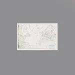
The item is a Custom Printed Map Tile accessory, which is designed for minifigures. This is a custom accessory featuring a detailed printed strategic map. This map depicts the Axis expansion in Europe, North Africa, and the Atlantic from 1939-1942. The red lines outline the vast territory controlled by or allied with Nazi Germany and Fascist Italy at the height of their power. It covers the Atlantic (showing U-boat activity), all of occupied Europe from France to the Eastern Front, and the campaign in North Africa.
Background: This map represents the period of maximum Axis expansion in World War II. Between 1939 and late 1942, Germany and its allies conquered most of the European continent, from the shores of France to the gates of Moscow and Leningrad, and pushed deep into North Africa towards Egypt. This map illustrates the “Fortress Europe” (Festung Europa) that the Allies would have to breach.
Reviews
There are no reviews yet