 military map – 3D Print for LEGO minifigure.")
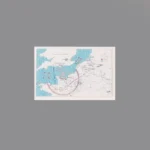
The item is a Custom Printed Map Tile accessory, which is designed for minifigures. This is a custom accessory featuring a detailed printed military campaign map. This map depicts the Allied Normandy Landing plan (Operation Overlord). It shows the English Channel, the southern coast of England, and the northern coast of France. It is overlaid with strategic red markings, including arrows showing the naval invasion routes and a large semi-circular line on the French coast labeled “COBRA,” which refers to the Allied plan for the breakout from Normandy.
Background: This map represents the strategic planning for Operation Overlord (the D-Day landings on June 6, 1944) and the subsequent Operation Cobra (the offensive to break out of the Normandy beachhead, which began in late July 1944). This type of map would have been used by high-level Allied commanders to plan the invasion and liberation of France.
Reviews
There are no reviews yet