
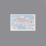
The item is a Custom Printed Map Tile accessory, which is designed for minifigures. This is a custom accessory featuring a detailed printed military campaign map. This specific map depicts the 1944 American advance into the Brittany Peninsula in France. The map shows the distinctive shape of Brittany, with red-shaded areas indicating the German-occupied coastal fortresses (like Brest, Lorient, and St. Nazaire) and blue arrows showing the U.S. Army’s advance.
Background: After the Operation Cobra breakout from Normandy in August 1944, General Patton’s U.S. Third Army was ordered to turn west and seize the vital ports of the Brittany Peninsula. While the U.S. forces rapidly overran most of the peninsula, the German-held ports proved to be heavily fortified “festungs” (fortresses) that held out for a long time, leading to difficult and costly sieges, most notably the Battle for Brest. (Note: The user’s filename mentions the U.S. Seventh Army, but it was the U.S. Third Army that led the Brittany campaign).
Reviews
There are no reviews yet